 Let me re-introduce myself…I’m Jeff of Lutz Getaway. I am now a RETIRED meteorologist with the NWS. While we try to figure out what is going on with my website, and I get some more equipment for my streaming/recording, I’ll post my weather things here.
With that in mind, here we go…
Whenever I would get into the office, I would look at a map analysis or do one, depending on the time I had. The easiest map for me to look at was the WPC interactive map, so here is the most recent one as I post this.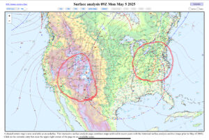 This is the most recent one that was analyzed at 4 am this morning. 09z is the time, which is done under the Universal Time, Coordinated (UTC) so that all of the observations and forecasts are coordinated. It’s just the universal time zone that scientists use to no matter where you are, all of the observations were taken at the same time.
I’ve circled some areas on the map, that I’ll talk about a little later, but for now I want to analyze another map. So, here is a map of the south that I analyzed around 9am (CDT). The observations are from 13z (8am CDT).
 With the map analyzed, my brain has an idea of where the issues of the day are. So I look at SPC and WPC to see where the national centers have issued for the day and the next couple of days.
As I noted earlier, the two surface low pressures were interesting. They ar both sitting underneath two upper level lows, which has formed a bit of a blocking pattern, an omega block. 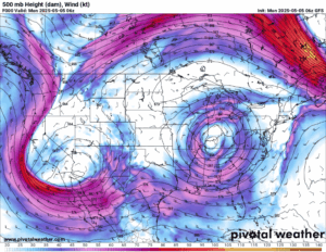 An injection of energy into the base of the low in the west, pushes them along. However, as the pattern moves, it begins to form a Rex block at the end of the loop. Which is an upper level high to the north, and an upper level low to the south. What does this mean? Rain under the low, or lows, and dry weather north. These can also linger for days, until the low fills, or another stronger piece of energy can force them along.
Hi-ho Jeff:
You bet we will follow you and your travels. So along with that I will give you my opinions on everything, but not WX content. When I served in the Navy one of the guys I served with was a master at communication. His mantra was, K I S M I F (Keep it simple, make it fun.) My friend went on to law school and became a successful Philadelphia lawyer. So that has been my mantra in both teaching and communication in several organizations. Keep it up and have fun.